Today's Weather - Monday, July 6, 2026
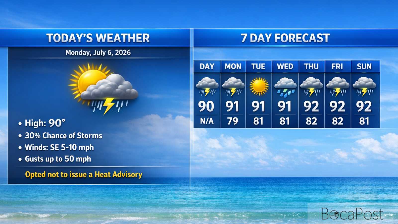
BOCA RATON, FL — Today will start mostly sunny and steamy, with afternoon highs near 90 and heat index values pushing up to around 106. Showers and thunderstorms become likely late in the day, mainly after 5 p.m., with lightning and brief heavy rain the biggest concerns. A few storms could also kick out isolated wind gusts around 50 mph. Tonight stays warm near 79 with storms mainly ending by mid-evening, though a few showers can linger
South Florida is set up for another classic July heat-and-storm day, and Boca Raton is right in the thick of it. The National Weather Service notes the atmosphere remains very moist and unstable, which is a key reason storms can grow quickly and dump a lot of rain in a short time.
That moisture also keeps the air feeling extra heavy, helping heat index values climb into the 103 to 108 range today. The main driver for storms will be the daily sea breezes.
As the Atlantic breeze pushes inland this afternoon, it will collide with other small-scale boundaries left behind by earlier showers and storms. Those collisions act like a spark, helping thunderstorms pop up and then expand.
While the highest storm coverage often ends up over the interior later in the day, Boca and the east coast metro can still see storms, especially late afternoon into early evening. Impacts to plan around: frequent lightning, brief street flooding where downpours repeat, and a few storms capable of isolated gusts near 50 mph.
Boaters and beachgoers can expect generally calm marine conditions outside of thunderstorms. Today, south winds around 5 to 10 knots and seas 1 foot or less are forecast nearshore, with light chop on the Intracoastal.
The main hazard will be storms late today and early evening: lightning, sudden wind gusts, and locally higher seas can develop quickly near any thunderstorm and along its outflow. Overnight and early morning, a few showers or isolated storms may stream over the Atlantic waters.
Midweek, southeast winds increase to 10–15 knots with seas around 2 feet, building to 2–3 feet late week; conditions can turn rough in and near storms.
Current Advisories / Watches / Warnings
- Opted not to issue a Heat Advisory today, figuring that early
- advisory level apparent temperatures (107-110) are expected, with
7 Day Outlook
- Monday (Jul 6): Mostly sunny and very hot, high near 90 with heat index up to about 106. Thunderstorms likely late afternoon and early evening; lightning and heavy downpours, plus isolated gusty winds.
- Tuesday: Mostly sunny and hot, high near 91 with heat index near 106. Lower storm coverage than Monday; a few afternoon storms possible after 2 p.m., with brief downpours and lightning.
- Wednesday: Mostly sunny and hotter-feeling with building heat risk. High near 91 and a warm night near 82. Only a small chance of a quick shower; most areas stay dry.
- Thursday: Sunny and steamy with highs around 91 and a warm, humid night near 82. Southeast breeze becomes more noticeable. Rain chances remain low, but heat stress risk continues to rise.
- Friday: Mostly sunny and very hot, high near 92. A few afternoon storms return (around a 30% chance), and the onshore breeze may gust near 20 mph at times.
- Saturday: Hot with highs near 92 and a better chance of scattered storms (around 40%). Expect typical summer timing—late-day downpours and lightning—while heat remains a concern between storms.
- Sunday: Mostly sunny and hottest of the stretch with highs near 93. Only limited storm chances indicated right now, but humidity stays high and the heat index can climb quickly by midday.
Get the latest Boca Raton Weather update for Monday, July 6, 2026, including heat index concerns, late-day thunderstorm timing, and a calm-to-choppy marine outlook near storms.