Today's Weather - Tuesday, May 26, 2026
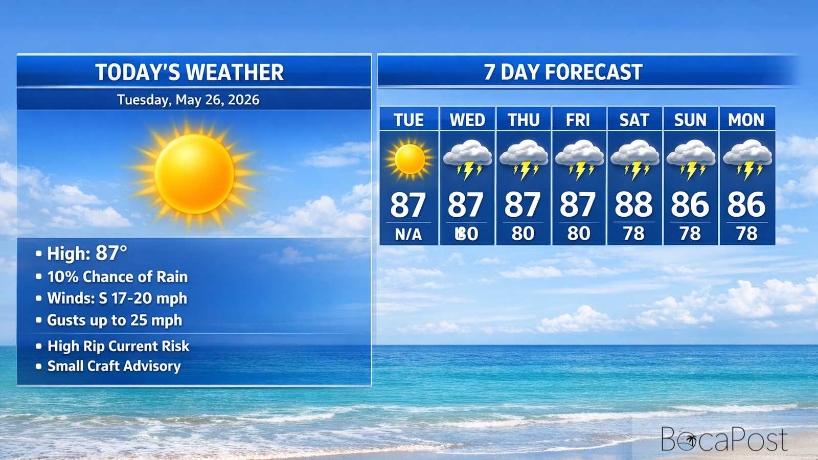
BOCA RATON, FL — Boca Raton will run hot and breezy today under mostly sunny skies, with highs near 87 and heat index values pushing close to 100. A stray shower is possible late this afternoon, but most of the day stays dry. Tonight turns a bit more unsettled with a higher chance of showers and a few thunderstorms toward daybreak Wednesday. Beachgoers should take the high rip current risk seriously along the Atlantic coast through Wednesday evening
South Florida is in the middle of a pattern change, and Boca Raton will feel both sides of it this week. For today, the National Weather Service says the “ridge” of high pressure is still the main player, which helps keep the atmosphere more stable and limits widespread storm development.
That’s why the forecast leans heavily sunny with only a small chance of a late-day shower, even though the southeast breeze will be strong enough to notice. The bigger story is the transition that begins Wednesday.
Forecast guidance discussed in the latest Area Forecast Discussion shows the protective high pressure weakening and shifting farther into the Atlantic. As that happens, winds gradually turn more southerly, opening the door for deeper tropical moisture to stream north into Florida.
In plain terms: the air over us becomes much more humid and storm-friendly. For Boca Raton and the east coast metro, rain chances increase but may lag behind the west coast at first, with the sharpest ramp-up expected later in the week.
Hazardous boating and beach conditions continue on the Atlantic side. A Small Craft Advisory remains in effect for the Atlantic waters through late tonight, with southeast winds around 15–20 knots and gusts up to about 25 knots, plus seas around 4–5 feet (occasionally near 6 feet).
Choppy conditions are expected in the Intracoastal in exposed areas. Along the beaches, strong onshore flow is maintaining a high rip current risk through Wednesday evening.
Later this week, winds ease and turn more southerly, but thunderstorms become more numerous—meaning locally higher winds and seas near storms and reduced visibility in heavy rain.
Current Advisories / Watches / Warnings
- High Rip Current Risk through Wednesday evening for FLZ168-172-173.
- Small Craft Advisory until 2 AM EDT Wednesday for AMZ650-651-670-671.
7 Day Outlook
- Tuesday: Mostly sunny, hot, and breezy. High near 87 with heat index near 100. Southeast winds 17–20 mph with higher gusts. Only a small late-day shower chance.
- Wednesday: Mostly sunny and still breezy, with a few showers or storms possible around midday. High near 87 and heat index near 100. Southeast winds remain gusty at times.
- Thursday: Turning noticeably wetter. Showers become likely later in the day with thunderstorms possible. High near 87. Plan for downpours and lightning, especially during the afternoon and early evening.
- Friday: Unsettled and stormy pattern continues. Showers and thunderstorms are likely, especially after midday. High near 88. Heavy rain could cause brief street flooding in poor-drainage spots.
- Saturday: Mostly cloudy with showers and thunderstorms likely, mainly later in the day. High near 86. A few storms could be stronger with gusty winds; keep an eye on changing conditions.
- Sunday: Periods of showers and thunderstorms. High near 86. Expect breaks between rounds, but have indoor options ready if you’re outdoors due to lightning and heavy rain.
- Monday: Continued wet pattern with showers and thunderstorms likely. High near 87. Repeated downpours may keep localized flooding concerns going where rain falls hardest.
Get the latest Boca Raton Weather update with today’s heat, breezy beach conditions, and increasing late-week storm chances.