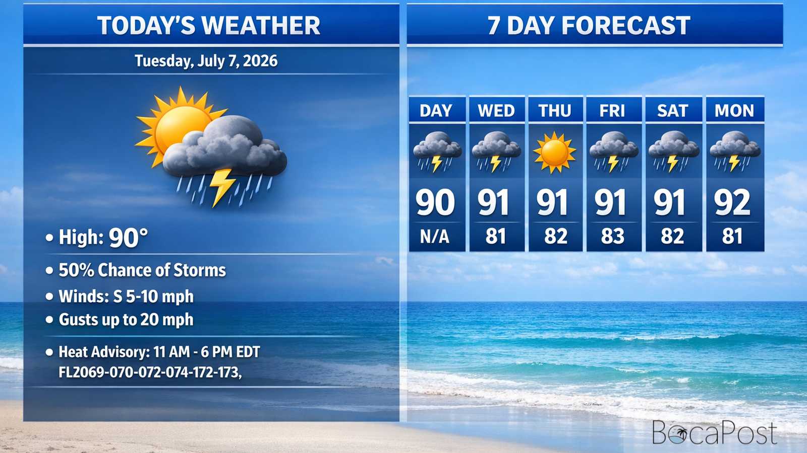
Today's Weather - Tuesday, July 7, 2026
BOCA RATON, FL — Expect a hot, humid Tuesday with a Heat Advisory in effect late morning through early evening. We’ll see a mix of sun and clouds, with scattered showers and thunderstorms developing mainly after 10 a.m. and into the afternoon. Not everyone will get rain, but any storm can bring frequent lightning and a quick burst of heavy rain. Highs will be near 90–91, with heat index values up to about 106 before storms and sea breezes offer limited relief
Today’s weather is being driven by a strong summertime ridge pattern over the broader Southeast, which keeps South Florida warm and steamy while steering our daily sea-breeze storms. The National Weather Service notes southeasterly winds becoming established as the ridge edges west, and that setup favors active sea breezes again today.
For Boca Raton, that means storms should pop late morning into the afternoon, but coverage will be uneven—some neighborhoods get a downpour while others stay dry and just bake. Because storms are expected to move along a bit faster toward the west and northwest, the best chance for repeated storms lingering near the immediate coast looks lower than on some recent days.
Still, the forecast calls for a 50% chance of showers and thunderstorms after 10 a.m., and any storm can produce dangerous lightning, brief street flooding in poor-drainage spots, and gusty winds. The bigger story is heat.
Even with some clouds and scattered storms, the air remains very humid, and the NWS expects heat advisory conditions across parts of the east coast metro. For Boca Raton, plan for a high around 90–91, but it will feel closer to 105–106 at times, especially late morning through mid-afternoon before storms become more widespread.
For boaters and beachgoers, winds stay generally out of the south to southeast today around 5–10 knots, with seas 2 feet or less nearshore and only a light chop on the Intracoastal. A few showers and thunderstorms are possible late morning into early afternoon; winds and seas can jump quickly in and near storms, with frequent lightning the main hazard.
Midweek remains relatively calm, but by Wednesday night into Thursday, southeast winds increase to 10–15 knots with gusts near 20 knots and seas building to 2–3 feet. Plan for a choppier ride later this week, especially in the afternoon sea breeze.
Current Advisories / Watches / Warnings
- Heat Advisory from 11 AM to 6 PM EDT Tuesday for FLZ069-070-072-074-172-173.
7 Day Outlook
- Tuesday (Jul 7): Partly sunny and very hot. Scattered showers and thunderstorms mainly after 10 a.m. High near 90–91; heat index up to about 106. Southeast breeze develops.
- Wednesday: Mostly sunny and hotter with fewer storms as drier air moves in. Only a slight shower/storm chance late morning. High near 91; heat index up to about 108.
- Thursday: Sunny and dry-leaning with building heat. East to southeast winds 8–13 mph. High near 91, but the broader region trends hotter; limit midday outdoor time.
- Friday: Still hot, with a better chance for afternoon storms returning (around 30%). Southeast winds 9–14 mph with gusts near 20 mph. Brief downpours and lightning possible.
- Saturday: Similar pattern—mostly sunny early, then a 30% chance of afternoon thunderstorms. High near 91. Storms may offer short-lived cooling but won’t reach everyone.
- Sunday: Mostly sunny and very warm. Lower rain chances overall, but typical summer humidity remains. High near 92; plan for peak heat stress during early to mid-afternoon.
- Monday: Hotter with a renewed 30% chance of showers and thunderstorms. High near 93. If storms are limited, heat indices can climb quickly—hydrate and take breaks.
Today’s Boca Raton Weather features a Heat Advisory, spotty afternoon storms, and a hotter, drier midweek trend.