Today's Weather - Monday, May 25, 2026
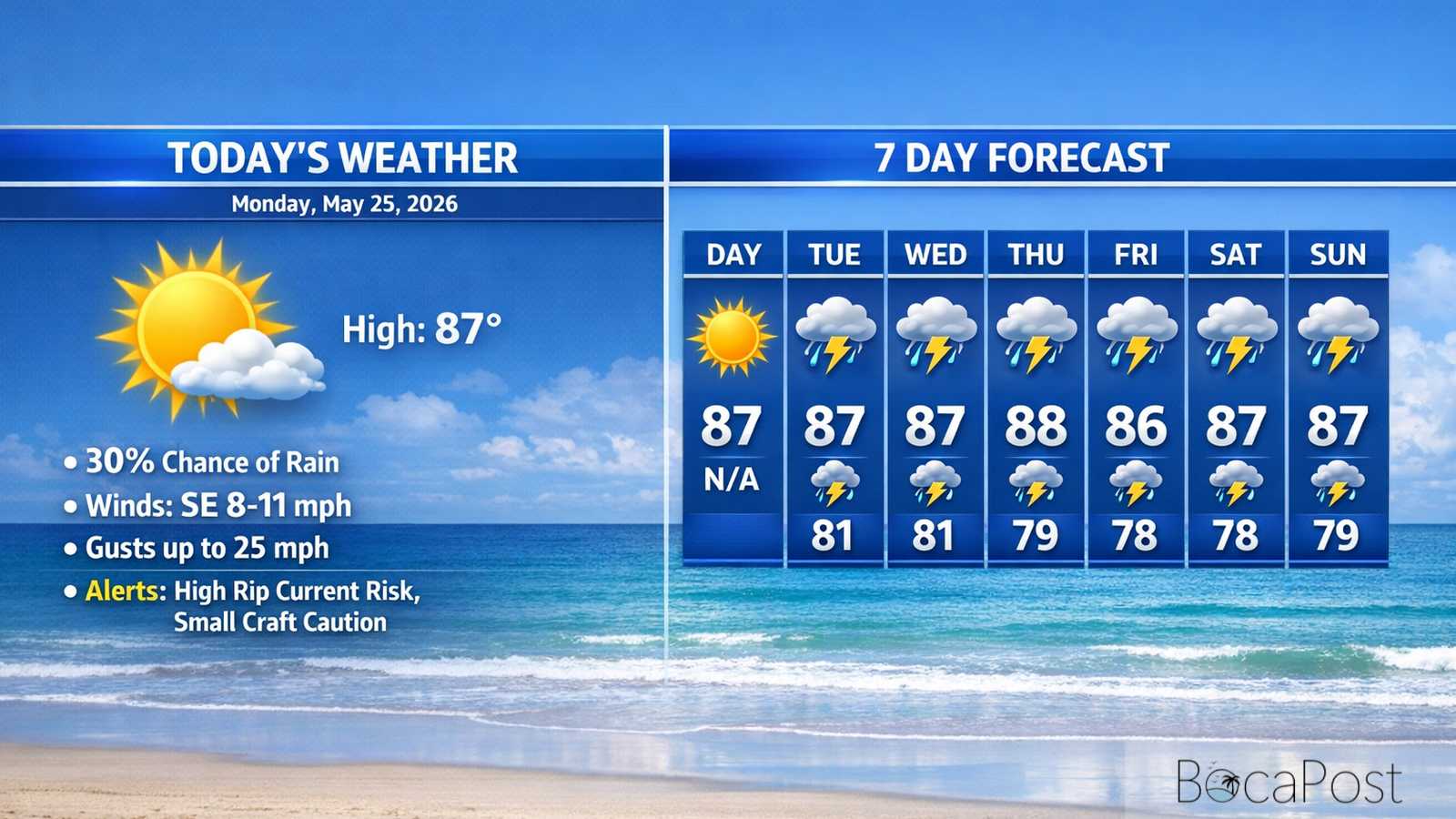
BOCA RATON, FL — Memorial Day in Boca Raton will be sunny, hot, and breezy, with a high near 87 and southeast winds gusting into the 20s. The beach is not a “set it and forget it” plan today: a high rip current risk continues along the Atlantic coast through Tuesday evening. Most neighborhoods stay dry through the daytime, but a few showers or storms could pop up late today or tonight. Rain and storm coverage increases noticeably by Wednesday, with a wetter stretch likely through the weekend
South Florida’s weather pattern is still being controlled by a broad area of high pressure, which is keeping the atmosphere fairly “capped” and limiting how many storms can grow tall and widespread early in the week. At the surface, that same setup is also driving a steady east-southeast breeze.
For Boca Raton, that means a classic early-summer feel today: lots of sun, a warm afternoon near 87, and enough wind to make it feel breezy at the beach and on the Intracoastal. Because the wind is coming in off the Atlantic, the sea breeze will be strongest along the coast and then push inland during the afternoon.
The National Weather Service discussion notes that the best storm chances through Tuesday favor interior and western areas, while the Atlantic metro (including Boca) stays mostly dry. Still, we can’t rule out a brief shower or an isolated thunderstorm late today or tonight, with a 30% chance overnight in the local forecast.
Heat is a growing concern. Even with the ocean breeze, humidity will push “feels like” temperatures into the upper 90s to around 100 across much of the east coast through midweek.
Boaters and beachgoers should plan for choppy conditions. Southeast winds run 15–20 knots today with seas 4–5 feet (occasionally near 6 feet) offshore from Jupiter Inlet to Deerfield Beach, and gusts can top 25 knots at times.
The Intracoastal will be choppy in exposed areas, especially during the afternoon. A high rip current risk remains in effect for Atlantic beaches through Tuesday evening, so swim only near lifeguards and avoid venturing out on sandbars.
Later in the week, winds ease and turn more southerly, but showers and thunderstorms become more common, with locally higher winds and seas near storms.
Current Advisories / Watches / Warnings
- High Rip Current Risk through Tuesday evening for FLZ168-172-173.
- Small Craft Should Exercise Caution (Coastal waters from Jupiter Inlet to Deerfield Beach out 60 NM).
7 Day Outlook
- Monday (May 25): Sunny and breezy for Memorial Day, high near 87. Southeast wind around 16 mph with higher gusts. High rip current risk at Atlantic beaches; most areas stay dry.
- Tuesday: Mostly sunny, still breezy and warm near 87–88. Only a slight chance of a shower or thunderstorm, mainly later in the day. Rip current risk remains high through Tuesday evening.
- Wednesday: Turning noticeably wetter. Partly sunny with more clouds and a higher chance of showers and thunderstorms, especially later in the day. Highs mid to upper 80s; downpours possible.
- Thursday: One of the wettest days of the week. Showers and thunderstorms likely with periods of heavy rain. Watch for ponding on roads and poor drainage flooding; highs around the mid-80s.
- Friday: Unsettled pattern continues with scattered to numerous showers and storms, especially afternoon and evening. Still warm and humid, but clouds may limit the peak heat a bit.
- Saturday: Mostly cloudy with frequent showers and thunderstorms. Rain may come in multiple rounds, not just a quick afternoon storm. Keep an eye out for localized flooding in heavier bursts.
- Sunday: Wettest trend holds with a high chance of showers and thunderstorms. Expect steamy air, slow travel at times in downpours, and lightning risk for outdoor plans.
Get the latest Boca Raton Weather update, including today’s breezy heat, rip current danger, and the midweek shift to widespread rain and storms.