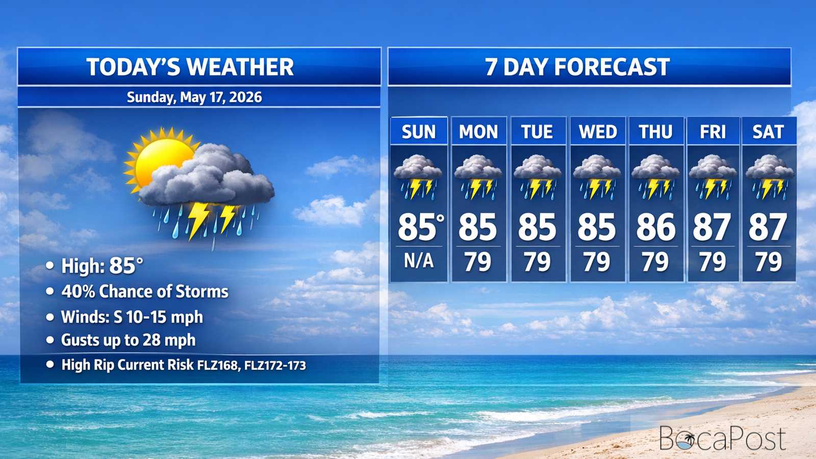
Severe Weather Alert - Sunday, May 17, 2026
BOCA RATON, FL (Boca Post) (Copyright © 2026) — South Florida is in an active late-day pattern Sunday, with scattered showers and thunderstorms expected to redevelop through the afternoon and evening. While the current Severe Thunderstorm Warning is focused on northwestern Collier County through 3:30 p.m., residents in the Boca Raton area should remain alert for fast-changing weather, brief damaging wind potential in stronger cells, and hazardous beach conditions as rip current risk increases along the Atlantic coast.
The National Weather Service in Miami said a severe thunderstorm was located near North Naples around 3:09 p.m., moving south at about 5 mph. The storm is capable of 60 mph wind gusts and quarter-size hail, with radar indicating the threat.
Impacts include possible hail damage to vehicles and wind damage to roofs, siding and trees. Locations listed in the warning include Naples, Golden Gate Estates, Naples Park, Vineyards, Golden Gate, North Naples, East Naples, Pelican Bay and areas near Alligator Alley.
For Boca Raton and the rest of the East Coast metro, the bigger message is preparedness: scattered thunderstorms are expected again Sunday afternoon and evening, and the NWS notes a low chance that an isolated storm could become severe. Even storms that do not meet “severe” criteria can still produce frequent lightning, sudden downpours that reduce visibility, and localized wind gusts strong enough to bring down small branches or toss unsecured outdoor items.
If storms approach Boca Raton, move indoors immediately at the first sound of thunder, secure patio furniture and loose objects, and avoid driving through water-covered roads. If a warning is issued for your area, take shelter in an interior room on the lowest floor of a sturdy building and stay away from windows until the storm passes.
Marine Update: Beachgoers should use extra caution: the NWS highlights a high risk of rip currents for the Palm Beaches through tonight, with the high risk expected to expand across the rest of the East Coast by Monday morning. In the Boca Raton area, swim near lifeguards, avoid entering the water if you are not a strong swimmer, and if caught in a rip current, relax, float, and swim parallel to shore to escape the current before heading back to the beach.
Important Information
- Severe Thunderstorm Warning remains in effect until 3:30 PM EDT for northwestern Collier County.
- Hazards: 60 mph wind gusts and quarter-size hail (radar indicated).
- Impacts: hail damage to vehicles; wind damage to roofs, siding, and trees.
- Precautionary action: move to an interior room on the lowest floor of a building.
Track the latest South Florida radar, warnings, and beach hazard statements from the National Weather Service Miami and local emergency alerts for Boca Raton updates.